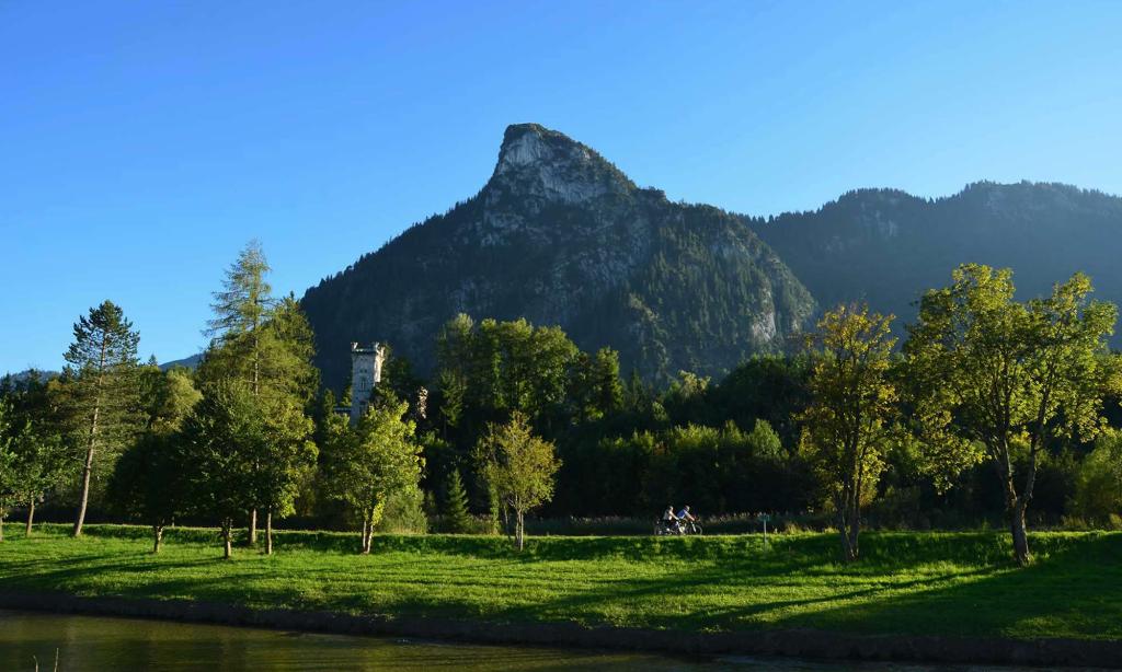
Towering over the village of Oberammergau is the Kofel, a Matterhorn-shaped mountain with an elevation of 1,342 meters (4,400 feet). The name Kofel means “cone-shaped mountain” in Celtic, and so hints at the different peoples who once passed through this mountainous part of Germany.
The Bavarians we’ve met in this picturesque town are well-versed in the art of hiking (known as das Wandern in German). As a result, they’re able to call off the names of these mountain peaks with the same sort of ease with which they ascend them. Coming from the Midwestern United States where hikes are typically through flat terrain, and well aware of my distaste for heights, I wasn’t sure I’d have the fortitude to reach the Kofel’s summit.

When I first came to Oberammergau and spotted the Kofel dominating the town’s landscape, I questioned if the mountain could easily be hiked. Many Oberammergau residents told us that it was “easy.” Some even mentioned that they’d taken their children along for the hike. These comments gave me some encouragement, despite the Kofel appearing to have sheer faces.
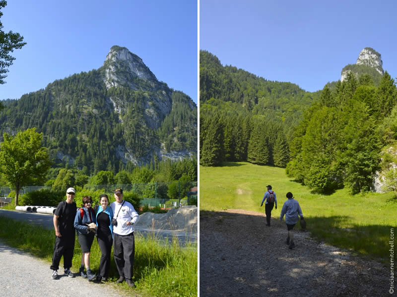
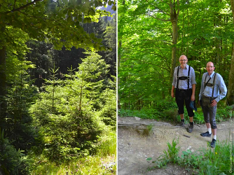
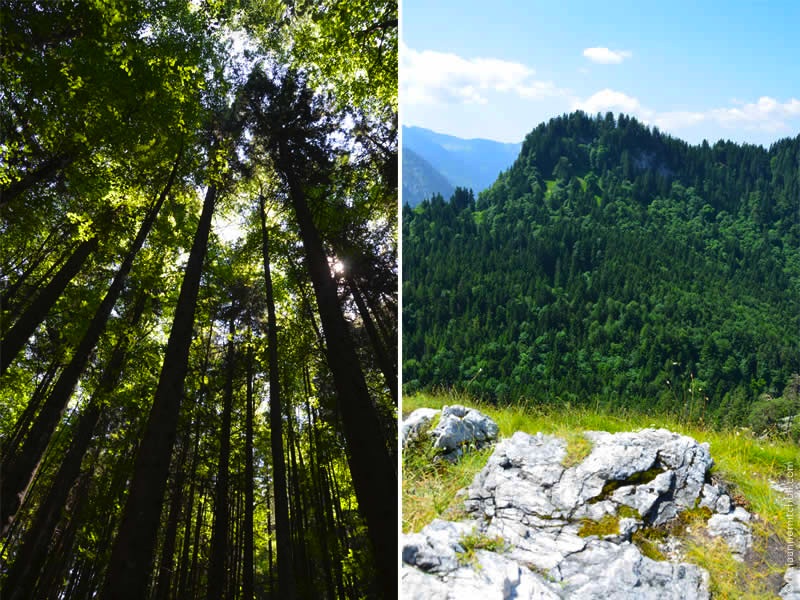
On an early summer morning, my parents, Shawn, and I set off to tackle the Kofel. Our hike would take us past a religious shrine carved into rock, then through a lush forested area where we met two hikers sporting Lederhosen. My mom and I grew intimidated when we encountered a scree field, which had to be crossed if we were to make it to the summit. Banishing all thoughts that doing so might start an avalanche, we eventually made it.
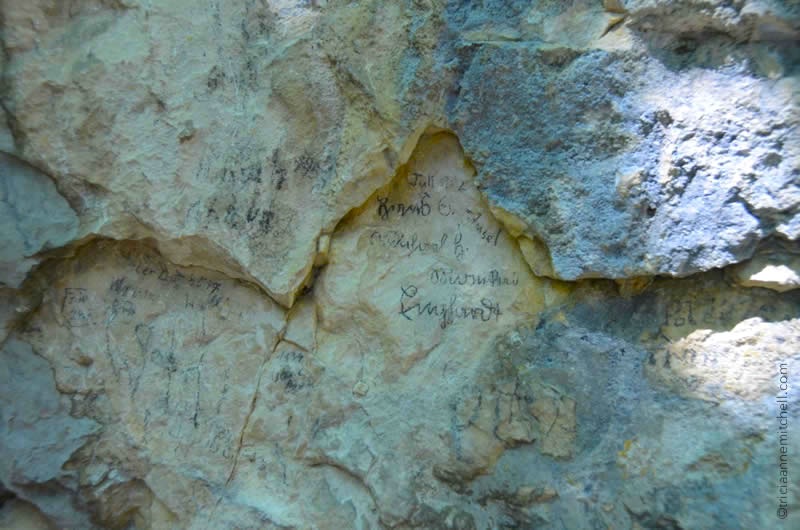
Another leg of the path wove past rock walls on which hikers had scribbled their names and the year of their ascent. With some entries dating back to the 1930s, we pondered what became of those individuals during World War II.
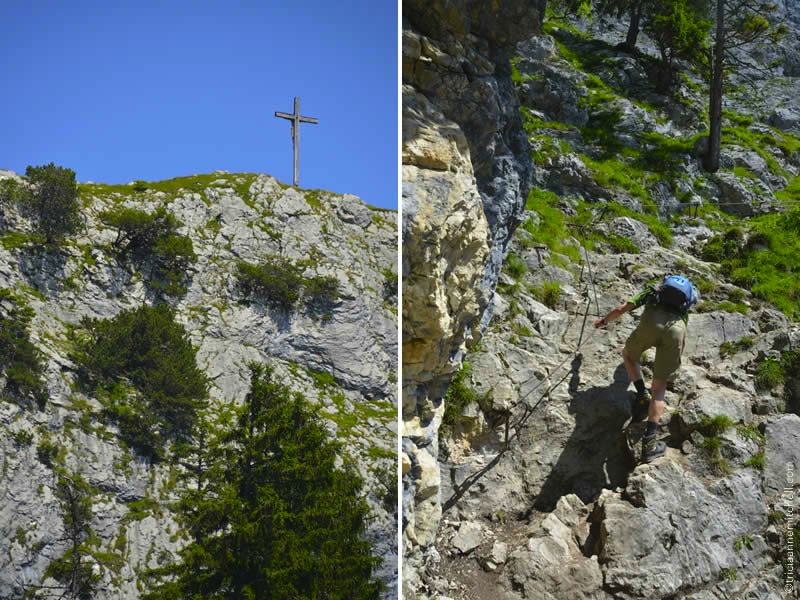
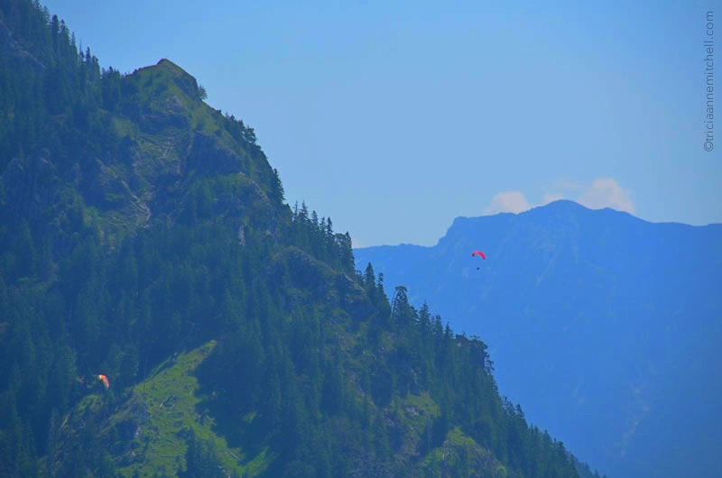
Eventually, nature’s canopy gave way to an unobscured view of a pristine blue sky. Here, we knew we’d made it to the leg that locals describe as being the most challenging. This part of the mountain was exposed. It had fixed metal cables attached to the rock face on which hikers could hold. We met a pair of women who said they were afraid to go further. We also encountered a man in his 70s who had just completed his third climb of the mountain. We even saw hikers accompanied by their large fluffy dog. The animal ran down the trail with ease.
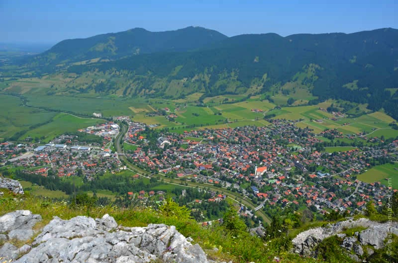
As we tackled the final leg of the Kofel, which is largely devoid of vegetation, we knew that we’d reached the top when we glimpsed the wooden cross on the summit. The views of the Ammergau Valley, neighboring mountain peaks, and a dollhouse-sized version of Oberammergau made the hike well worth it.
Later, we learned that we’d forgotten to sign the guest book at the top of the Kofel, a practice that’s customary in the Bavarian hiking world. Perhaps that means a second ascent is in the cards for us soon.
Skip Ahead:


Where in the World?
Planning Pointers:
How difficult is the Kofel hike? How long does it take?
The overall elevation gain is about 505 meters (1657 feet). The Kofel’s elevation is 1,342 meters (4403 feet), and Oberammergau sits at an elevation of 837 meters (2746 feet).
If you are active, this hike is somewhat easy. However, there are a few sections that you might find difficult if you’re scared of heights. The first part of the climb takes you through a lovely forested area.
About half-way to the summit, you’ll encounter a scree field, which some might find disconcerting.
The last segment of the hike involves ascending the exposed section of the mountain. There are fixed metal cables (Klettersteige / via Ferrata) here to which you can hold on. Those with a fear of heights — something I’m not fond of — might find this leg of the hike challenging. At the time of our climb, one or two small sections of the cables had become dislodged from the rock, making it possible to get startled or off-balance. I’m sure they’ve long ago been fixed.
There are several routes that you can take to get to the Kofel’s summit. We started at the Döttenbichl parking lot, near the Oberammergau Cemetery and then crossed the Kälberplatte meadow. This more direct route generally takes approximately 1.5 hours, but it took us a bit longer since we stopped to take breaks and photographs, and to mingle with other hikers.
To return to Oberammergau, we hiked via a different path known as the Königssteig (King’s Trail). The return journey was considerably longer — approximately 2.5 to 3 hours.
As you would when going hiking in any unfamiliar area, be sure to exercise caution. Unfortunately, it is not uncommon to hear emergency rescue helicopters and personnel attending to injured hikers in Oberammergau.
- For more Kofel hiking resources see: Summit Post & Hike & Bike.
- Also, take a peek at this stunning panorama shot, which shows the Kofel and neighboring peaks at sunrise.
What should you pack for your Kofel hike?
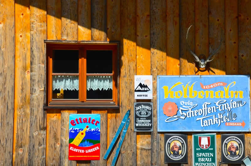
There are no drinking fountains or vendors along the route. Even though Shawn and I had packed a few liters of water, we’d exhausted our supply by the time it came time to descend. On the way back down to Oberammergau, we stopped at the Kolbenalm, a family-owned restaurant, for cold, bubbly water.
Here’s what I recommend packing:
- a sufficient amount of water
- snacks
- trekking poles (We didn’t have any during our Kofel hike. However, we have since used them for subsequent hikes in Croatia and Montenegro, and found them to be helpful for balance and alleviating impact on our knees.)
- layered clothing. The day started out cool, so we were happy we had a bit of outerwear for the shaded climb up. However, as we kept working our way up into the sunshine, it was nice being able to take off a layer.
- sun protection: sunglasses, sunblock and hat.
- tick protection (Lyme Disease is present in Germany, with most cases being reported in the south of the country — in particular Bavaria. Note that Oberammergau is in Bavaria.)
- camera — the views are extraordinary!
Accommodation in Oberammergau
Here are accommodation options in Oberammergau, organized by theme.
Looking for more Oberammergau trip-planning inspiration?
See my comprehensive guide to Oberammergau, which covers everything from museums and more hikes to festivals and supermarkets.
Photography & text © Tricia A. Mitchell. All Rights Reserved.
Outstanding!
Thank you, Jono. Are you also an avid hiker?
Yep, I grew up in the Blue Mountains in Australia so I was always hiking. Stunning scenery at home ;)
Would love to make it there someday – as of now, Australia has still been an elusive country. :)
This would delight The Good Husband. Nothing climbing a mountain to make his day. Cheers V.
Virginia, you two will have to come over the next time you make a pilgrimage to Paris. :)
I love this part of the country, although I’ve yet to spend as much time around Oberammergau. I like the verb “wandern”, but there’s also “spazieren gehen” or one of my favourites “bummeln”. I really like the idea of the valleys huts or “Hütten” where one can either bunk overnight and/or have a well-deserved rest and fuel stop. Thanks for your beautiful tour up and down the Kofel, Tricia!
‘Bummeln’ is a new word for me – ‘stroll’ I like it. My parents have long favored ‘spazieren gehen’ and their dogs almost responded better to that cue than its English equivalent. :) I haven’t yet done any hut hikes, but think the idea sounds utterly relaxing. Can you recommend other spots in this part of the country to explore, Henry?
Another ‘height’ conquered, Trish. Wonderful pictures. Felt like I was hiking along with you.
:) Glad you could join us virtually, Mary Ann. We were hoping to go for another hike today, alas the ground is rather soggy after all the rain we’ve been getting.
Wow, quite the adventure! Great post Tricia!
Thanks, Tina. After my unsuccessful climb of the bell tower in Croatia, I was pleased to make it up here!
Reblogged this on Just Go Places.
Thank you for sharing this post on your site, NYonLiving. Wish you a wonderful weekend.
Stunning views Tricia. I think coming down holding on to the cable might be scarier even than going up that way!
Melinda, I must confess that my descent wasn’t always pretty, but I made it down. :) Now what I know what to expect at the top, I might even try the climb again someday, but for now, I’m eager to explore other local summits.
Lovely. And, i’m out of breath now…
Alessandro, you never cease to make me smile. Since you travelled vicariously with us up this mountain, we’ll have to send a refreshing beverage your way. Are you a fan of Bavarian beer? :)
It looks like you took a nice hike in a very beautiful location. Thank you for sharing.
A pleasure to share the tale, Gerard! Now, if only the weather would cooperate, as we’d love to get just one more hike in this autumn somewhere around this area. :)
Oh how lucky, Tricia, you got a sunny day!! Love all your posts from the Oberammergau, they make me feel home immediately. I tried to answer your questions from your last post about any fall events, but for some reason WP didn’t made it through to you. So here again, there is “Erntedankfest” sometime in October , where the farmers bring the herds of cows from the “Alm” down to their stables, it is like a procession. It has the meaning of like thanking for the crop of the summer , cows are sported with their beautiful bells around their necks and lots of fall flowers, it is really beautiful. All the locals are out and about in their folkloric outfits and even a priest blesses the cows. Hope you have a chance to see this. Auf Wiedersehen!!
Cornelia, thank you for taking the time to share these details with me – twice! That’s quite thoughtful of you. Unfortunately I think we might have just missed it. Sunday was ‘Erntedanfest’ here in Oberammergau. It was a bit rainy so we didn’t go out to explore if any special activities were taking place. We are planning on watching the Leonhardiritt event in Unterammergau though. Do you recall seeing that?
Congratulations Tricia, You are one brave and talented soul! That scree field looks pretty treacherous – so glad that you conquered it! ~Terri
Belated thanks, Terri. Though the scree field didn’t faze the men in our climbing party, my mom and I weren’t very amused. :) It’s a delight to see the mountain every day though, and know we conquered our fears!
Great shots from a great hike.
Thank you, Mark. Hard to believe that this mountain is dressed in snow as of last night. Winter came early this year… Do you do much hiking when you’re back home?
Not much at the moment, I’m trying to start a new business and that is taking up so much of my time.
We’re trying to do the same, Mark. What type of business?
A shipping/marine venture, buying a boat for work in the wind farm/construction area.
Sounds like an interesting venture, Mark. Wish you much luck!
Judging by these photos, making it to the top of the mountain is a real achievement. Well done Tricia. I’m not sure I would brave the last part with the cable to hold on to. It looks a bit precarious.
Carol, I wasn’t sure I’d make it up there either, but when I saw some four-legged friends and children who did so, I knew I could tackle it. :) Most of the locals here seem so courageous when it comes to hiking what to me are fairly high spots! Guess it’s all what one is accustomed to.
What an adventure. That last bit with the cable is a little scary. Reminds me of climbing Uluru. (Yes, I know that’s not a right thing to have done but it was decades ago and before the aboriginal rights were being asserted as strongly as they were later. And I was an ignorant youngster.)
It was, Rachael. :) You certainly have done a lot of globetrotting, haven’t you? I haven’t yet been to Australia, but Uluru looks incredibly dramatic. I’ve read conflicting accounts about the view from the top – some say it is quite special, others say that the view is not so spectacular. What did you think?
Hmm, I would say the view from the very top was nothing special. But the view from the top of the first climb, looking down past where you’ve just been, is vertiginous in the extreme. I will post it some time. ;)
I look forward to it, Rachael!
Love me or hate me, I have nominated you for a bloger-to-blogger award. Read all about it here: http://wp.me/p2V9GN-8A
I’m flattered, Laura! Thank you for the recognition. :) I’ll be in touch shortly once things here slow down a bit.
Wonderful, Tricia! What a great hike. You should frame that photo of you and Shawn with the valley behind you. ;)
A good idea, Ruth! Now we can all feel a sense of accomplishment when we look up at Oberammergau’s signature mountain. (This one towers over my parents’ home and is emblazoned on many local details – from Lederhosen suspenders, to pharmacy signs, etc.)
Do you do much hiking or climbing in CO?
Your parents are lucky to have that view! I hike almost every day here in Colorado. It’s one of the main reasons we moved to this remote area. I love it! ;)
Indeed, they are! Recently, my mom successfully hiked to the top of the Kofel, and it gives her much satisfaction when she sees it. :) What winter sports do you appreciate in CO?
That’s much better walking weather than we’ve got today, Tricia. :) Your site looks beautiful! It’s hard to know where to dip in and start.
Here’s hoping sunnier skies are on the horizon then, Jo! Thank you for your thoughtful comment about my site. You’re very observant that I’d been tinkering with it. I do hope it’s not challenging to navigate though. For the most recent posts, a click to the Blog tab will take you there. :)
Not a problem, at all. I like the style. It’s like being outside a sweet shop and choosing :)
That’s cute, Jo. Have a splendid day, neighbor to the northwest!
Thank you for this web page of the Kofel and Oberammergau. Stationed in Germany with the USAF, I visited the area several times and climbed the Kofel in 1953. One of the local woodcarvers put me up to it. Said, “You haven’t really visited Oberammergau unless you’ve climbed the Kofel”. My last visit to Ober was in 2005.
Michael, how nice to hear from someone else who’s tackled the Kofel. I suppose we were quite inspired by the many locals who’d climbed it, and other neighboring peaks, several times. It seems to be a rite of passage there. Was there a book at the top of the Kofel (attached to the cross) in which you could sign your name? Last summer I wasn’t aware of this guest book of sorts, so I missed out on the chance to sign it. It seems a return is in order to document that I was there. :)
It’d be fascinating to hear your tales of how Oberammergau has changed over the years…
I was a 20 year old soldier stationed in Germany in 1968 and I was sent to Hawkins Barracks for some training. From our barracks window we could see this mountain with a cross on it (it was Kofel but we didn’t know it at the time) and a few of us decided to try to climb up the mountain. We did not know there was some kind of walking or climbing path that you could walk up so what we did was climb straight up the mountain while holding on to trees for our lives, ha, ha! We made it to the top and we heard voices and found out THEN that there was a path you could follow. I have some photo’s of our climb to the top….
Hi John, what a treat to read your anecdote! As someone who is scared by heights, I do commend you for your bravery. Do you recall if you signed the book at the top of the mountain to show that you successfully ascended it? When we climbed the Kofel back in 2013, I didn’t know about this book, so I suppose I technically must return. :)
When was the last time you were in Oberammergau? It would be fascinating to see your images from that intrepid climb!
Thank you once again for reading, and for sharing your tale.
Thanks for replying. I was only in Oberammergau that one time in 1968 for I think a week or two of training in the army. For some reason the book you mention does sound familiar but I don’t remember if I ever signed one. I have some pitcures I can send you if you send me your e-mail address. Mine is….. johnmil51@aol.com
Greetings again, from snowy Oberammergau. The mountain peak that you climbed in 1968 is dusted with snow and fog as I type this. :) I’ve just sent you a message by email. Wish you a terrific Tuesday.
Almost 2 years later on, and I realized (1) I commented, but (2) I didn’t answer your question. I adore Tegernsee. In my past life as astronomer and one-time staff of a Max-Planck-Institute, the MP has a “castle”, Schloss Ringberg, near Tegernsee. It is a beautiful area, and an area to which I must return. I also really love Garmisch-Partenkirchen (GAP), and I still feel I’ve missed out on far too much. I haven’t wandered as much in the area (or made the hike into Partnachklamm, etc.), or taken the train and explored Mittenwald, or taken the same train to Innsbruck (for a day or two), or taken the regional train from GAP to Reutte in Tirol. I admit: I’ve been to GAP twice, and both times up to Zugspitze I went: 1st time without a camera, and 2nd time with a camera. At least I’ve “cased” out many places I’d like to see. We also know and understand that these parts of Bayern show very different sides in winter and in summer: double the fun!
Henry, like you we have much more of this region to explore. I’ve been wanting to get to Partnachklamm and Mittenwald, eager to learn more about violin-making at the latter. There’s much to see, reminding me of your earlier comment about somehow feeling guilty about returning to places you’ve already visited (or lived in) before.
Schloss Ringberg sounds and looks intriguing. Must one have some connection to the Max-Planck-Institute in order to visit it?
And, it sounds as though you’ll be seeing that snowier side of Bayern in a few months though, won’t you? :)
Hi, Tricia. Like I said, it’ll be a little tough to visit now I’ve become reacquainted with foliage, flowers, blue skies, and that yellow globe occupying a larger duration of the day. ;) Forgot about the Geigenmacher in Mittenwald! Aaaaand now I’m drooling over the GAP area again. As far as I remember/know, Schloss Ringberg is owned and operated by the Max-Planck-Gesellschaft so staff at their institutes can use the facility for workshops and small meetings (http://www.schloss-ringberg.de/start), but the castle itself is relatively young. I remember one summer meeting and a group of us gathered at a Brauhaus in Tegernsee, and we ordered a meat and cheese platter. The “Steinkäse” was … “odorous”, known also locally as “Stinkkäse”. :P
Funny, I’ve heard of Stinkkäse, but have never tried it. :) Though it sounds as though you’ll be missing the warmth of summer, think of all the Christmas market ambience you’ll be able to soak up! We’ll keep you posted what we discover in the coming weeks, but for the most part, we’re staying local in the Oberammergau area.
Well … my colleagues from France were enthusiastic about the Stink … er … Steinkäse, while I and others looked on in amused horror. I was reading about Bavaria earlier today, and it got me dreaming again, dreaming of those mountains. I’ve to decide how much of December I might cover; I’ll keep you posted as well.
Henry, lately we’ve been enjoying some aromatic French cheese that probably doesn’t come close to Steinkäse’s pungency, but I suspect that’s a good thing. :) For our salads, we’re just loving this French chèvre (goat cheese) that we found at the German market. Yes – definitely keep us posted as to your winter travel plans. The planning stage is always fun!
Re John DiSpirito’s hike up Kofel, I was also in Oberammergau for four weeks in 1968 (tdy with US Army, permanent station near Pirmasens). Sitting at the top of the Kofel, seeing the village and the valley before me, and listening to the church bells below, was the most exquisite moment of my year and a half in Germany. For me it is only comparable to the hike to the top of Half Dome in Yosemite in California. I vowed to return. I will next spring, with my wife and another couple, after only 51 years. At age 74 I hope to again make that wonderful hike. I also look forward to Garmisch-Partenkirchen, Zugspitze, the Eibsee, and so much more in that beautiful country. My wife will also be returning after nearly as long. She worked for five years in Pforzheim.
Hi David, by chance, did you cross paths with John (the other commenter) in 1968? What a small world.
Thanks for sharing your memories from making it to the top of the Kofel. I remember also feeling quite moved when I reached the summit. I don’t know how much of that was due to the natural beauty or the fact that I overcame some fears to make it to the top. The section with the iron cables (via ferrata / Klettersteig) is what made me nervous.
I have not yet been to Yosemite but from what I’ve read, the Half Dome ascent looks gorgeous but intimidating — especially if a person is afraid of heights. It’s interesting that the two climbs remind you of each other.
It sounds like you and your wife have a special trip awaiting you! Here’s hoping that you have gorgeous spring weather when you return to Bavaria this spring. Spring and autumn are the best seasons to be in Oberammergau, unless you’re fond of snow sports and shoveling. :)